NavStation is a software suite for all recreational sailors. It has been designed as a modular, low cost solution without the need to buy expensive electronic charts. Versions will be available for PC (Windows) and Pocket PC.
Latest News:
NavStation Tides for Smartphone is now available.
NavStation version 2.3 for Windows Mobile 2003 is now available.
Fix for WM 2003 SE toolbar icons
New Utilities module for common calculations and conversions
New Maintence module to keep track of outstanding maintenance tasks
Improved and simplified installation routine
The application may be downloaded for a free 30 day evaluation. All available modules are included in the download, however modules may be purchased individually as required. On purchase, a registration code is supplied to remove any trial restrictions.
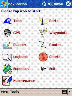
The following modules are now available for the Pocket PC:
- Tides – Worldwide tide height predictor.
- GPS – GPS repeater with NMEA capture and waypoint and route exchange facility.
- Planner – Passage planner to calculate passage times, course to steer etc. taking tidal streams into account.
- Logbook – To record all passage details, including automatic updates from GPS/NMEA input.
- Expenses – to record all expenses.
- Maintenance – to record all repairs and maintenance tasks.
- Ports – to maintain port information, including tidal harmonics.
- Waypoints – to maintain waypoints for passage planning.
- Routes – to maintain routes for passage planning
- Charts – to maintain chart details, including tidal stream information. Coastal outline images can be created for any area at no cost.
- Utilities – for common calculations and data conversions
The following modules are now available for the Smartphone:
- Tides – Worldwide tide height predictor.
System requirements:
- Microsoft Pocket PC (Windows CE 3.0 or later)
- .NET Compact Framework
- 500KB memory for program files (may require additional memory for runtime components)
- 1.4MB memory for full worldwide data files (may be located on a storage card), however this can be significantly reduced by removing data for unwanted regions.
- NMEA compatible GPS (for GPS functions)
What do YOU want from your navigation software?
Please contact us with your ideas and comments.